Cloud-native content services
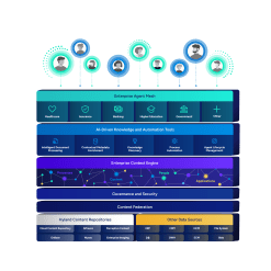
Deploy a modular, scalable architecture to manage large volumes of documents and optimize the flow of information across the enterprise.

Harness the power of a unified content, process and application intelligence platform to unlock the value of enterprise content.
Learn more
Automate your document-centric processes with AI-powered document capture, separation, classification, extraction and enrichment.
Learn about Hyland IDPIt's your unique digital evolution … but you don't have to face it alone. We understand the landscape of your industry and the unique needs of the people you serve.
 Overview of industries
Countless teams and departments have transformed the way they work in accounting, HR, legal and more with Hyland solutions.
 Overview of departments
We are committed to helping you maximize your technology investment so you can best serve your customers.
 Overview of services

Discover why Hyland is trusted by thousands of organizations worldwide.
Hear from our customers
Our exclusive partner programs combine our strengths with yours to create better experiences through content services.
Overview of partners
Join The Shift newsletter for the latest strategies and expert tips from industry leaders. Discover actionable steps to stay innovative.
Register now
Hyland connects your content and systems so you can forge stronger connections with the people who matter most.
Learn about HylandWith our modern, open and cloud-native platforms, you can build strong connections and keep evolving.
 Dig deeper
Modernize operations with an extensible, scalable and cost-effective platform for content, process and governance.

Harness the power of digitization, automation, cloud-native and open source technologies for the mission-essential needs of civilian and defense agencies.
Deploy a modular, scalable architecture to manage large volumes of documents and optimize the flow of information across the enterprise.

Automate the records life cycle from capture through file disposition and destruction with the only platform certified to the DOD 5015.02 Chapter 3 standard.

Drive operational efficiencies and reduce manual work for content and records management processes with RPA, AI and ML.

Empower enterprise IT to build tailored, customized solutions and deliver modern, personalized user experiences with open standards and open APIs.

Meet records management and open government compliance standards — including ISO 15489, ISO 16175, FOIA, U.S. DOD 5015.02 CH2 and CH3, EgovG, and MoReq.

Manage records in their current location and search for content across disparate systems, without the need for costly, time-consuming “big bang” migrations.

Simplify and speed information request submissions and fulfillment with online capabilities and digital delivery.


The U.S. Department of Defense’s new approach is a “paradigm shift” for federal agencies. Find out why Hyland meeting key compliance standards set by the DOD is an important step in our commitment to meeting agencies where they are.

Government organization reduces publication cycle times by 40% and increases productivity with Hyland’s Alfresco platform.

Discover how a leading U.S. government agency leveraged Hyland Alfresco to transform its content management approach with an innovative enterprise-wide solution. By implementing an EDMS and consolidating vendor contracts, it achieved significant cost savings and operational efficiency.

U.S. agency partners with Hyland and CGI Federal to digitize its processes and create a multipurpose records repository. Find out why Hyland Alfresco was the ideal solution.
We have received your message and will be in contact shortly.
We have received your message and will be in contact shortly.